Our Digital Library contains 71 244 digital objects
Object
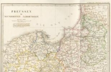
Title: Atlas zur historisch-comparativen Geographie...
Description:
Atlas geografii historyczno-porównawczej autorstwa m. Toeppena. Zawiera 6 map, w większości zaprojektowanych przez Toeppena, przedstawiających terytorium Prus w różnych okresach historycznych, od czasów pogańskich do XIX w. Pierwsza mapa zawiera odręcznie spisane objaśnienia do legendy.
Publisher:
Place_of_issue:
Format:
Identifier:
oai:dlibra.bibliotekaelblaska.pl:4275
Source:
Language:
Prawa:
Domena publiczna (public domain)
Object collections:
Last modified:
Oct 3, 2018
In our library since:
Oct 9, 2009
Number of object content hits:
2 645
Number of object content views in DjVu format
2468
All available object's versions:
https://dlibra.bibliotekaelblaska.pl/publication/3228
Show description in RDF format:
Show description in OAI-PMH format:
| Edition name | Date |
|---|---|
| 1858, Toeppen Max, Atlas zur historisch-comparativen Geographie... | Oct 3, 2018 |
Objects Similar
Toeppen Max
Toeppen M.
Toeppen Max
Toeppen M.
Toeppen, Max Pollux
Toeppen Max
